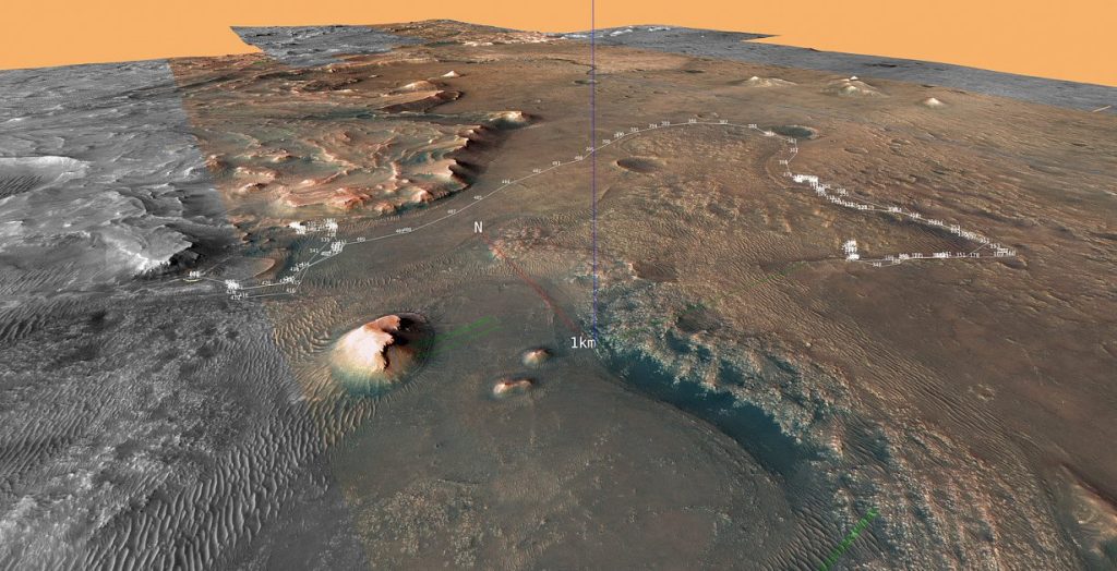
The Mars rover Perseverance landed on the Red Planet a little over a year and a half ago. Since then, NASA’s Mars 2020 mission has been sampling rocks and taking pictures. While the samples will not be brought to Earth for several years, experts from Joanneum Research in Graz and VRVis in Vienna are already making high-resolution images of Mars in 3D for geological research.
The Perseverance rover, which is the size of an all-terrain vehicle and weighs about 1,000 kilograms, was placed in Jezero Crater on Mars in February 2021, Gerhard Baar, a 3D visualization expert at research firm Joanneum Research (JR), said in an interview with APA. . Scientists hypothesize that about 3.5 billion years ago there was a deep lake at this point, which emptied and filled again several times over time and provided the right conditions for organic life. They hope the Mars 2020 mission will provide them with a better understanding of the planet’s geology, climate and history.
A team of experts from Joanneum Research’s Image Analysis and Measurement Systems research group evaluates impedance images and compiles the captured images into a 3D model. The technology was developed by Joanneum Research. A few days after landing, the staff of JR and the Vienna Research Center for Virtual Reality and Visualization (VRVis) presented the first video, about a minute and a half long – simulating a flight over the surface of Mars at the landing site of the Mars rover. It was created from about 100 pairs of images from the Mastcam-Z stereo cameras on the rover mast and can now also be seen on YouTube, Paar reported. The Austrian assessments mainly support the 3D measurements of geological researchers. More than 20 aerial videos have been created to date, Barr described.
The stream of high-resolution 3D images being called up every day hasn’t stopped since then. “The rover has traveled about 13 kilometers so far, from the landing site to the southern formation, and then back to the landing site and for a few months now into a river delta that formed millions of years ago,” Barr said. The images taken by the camera so far have shown a variety of terrain types: “From sand dunes to mountain ridges with sudden breaks. In the latter you can see outcrops, i.e. exposure of geological formations,” Barr summed up.
The images recorded by the cameras are sent back to Earth via a constellation of satellites known as the Deep Space Network. “The data is automatically fetched daily from the ASU server,” Barr said. The data analysis itself must be done quickly so that the rover can be assigned new tasks and no valuable on-site time is lost.
“Everything works amazing, the transmission quality has been good from the start,” Barr said enthusiastically. “We acquire the images, our automated evaluation software generates 3D models, and the 3D models can then be visualized using VRVis,” the Graz expert summed up. Paar’s team uses images captured by two high-performance stereo, color and zoom cameras on the rover’s nearly two-meter mast to describe each pixel in three dimensions, creating what are called coordinated point clouds and, finally, visualizations.
Funding for the Austrian activities was recently extended until 2024 by the research promotion agency FFG: “We will certainly be able to continue our assessments over the next two years,” Barr said. To date, a group publication and another new one have appeared in the journal “Science Advances”. The latter provides mapping and interpretation based on the first 3D 360-degree panoramic images of the landing site and crater floor. A variety of rock types and geological units are found. Cartography provides evidence of a volcanic origin for many of the rocks and outcrops. (appa)

“Social media evangelist. Baconaholic. Devoted reader. Twitter scholar. Avid coffee trailblazer.”


More Stories
Longest jets in the universe discovered – giant particle streams as long as 140 Milky Way galaxies in a row
New method reveals 307 supernova remnants
Snapchat is upping the ante on augmented reality glasses